


|
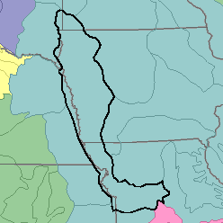
MLRA 107 - Iowa and Missouri Deep Loess HillsIowa, Kansas, Nebraska, and Missouri53,810 km2 (20,770 mi2) |

|
Elevation and Topography:
Elevation ranges from 200 m along the Missouri River flood plain in the south to 500 m on the highest ridgetops in the north. This rolling to hilly, loess-mantled plain is intricately dissected. Small valleys have narrow flood plains, but the larger valleys have broad floors. Local relief is mainly several meters to more than 50 m.
Soil Landscapes | Soil Climates | Soil Datasets | Personnel | Site Map
Comments and Questions
12/16/98