


|
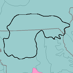
MLRA 109 - Iowa and Missouri Heavy Till Plainlowa and Missouri37,110 km2 (14,330 mi2) |
|
Soils:
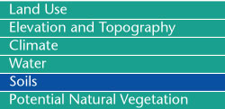
Most of the soils are Udolls. They are deep and have a medium textured surface layer and a fine textured subsoil. They have a mesic temperature regime, an udic moisture regime, and montmorillonitic mineralogy. Somewhat poorly drained, nearly level to moderately sloping Argiudolls (Haig series) and Ochraqualfs (Kilwinning, Kniffin, and Pershing series) and nearly level to moderately sloping, poorly drained, Argialbolls (Edina series), are on upland divides on loess-covered till plains. Somewhat poorly drained, gently sloping to strongly sloping Argiudolls (Adair, Lagonda, and Lamoni series) and poorly drained, gently sloping to strongly sloping Argiaquolls (Clarinda series) are on convex side slopes with a thin mantle of loess or pedisediment over glacial till. Well drained and moderately well drained, moderately sloping to steep Argiudolls (Shelby series) and Hapludalfs (Armster, Armstrong, Gara, Keswick, and Lindley series) are on side slopes on clay loam glacial till. Moderately well drained Hapludolls (Kennebec and Lawson series) and Udifluvents (Nodaway series) are on silty alluvium flood plains. Poorly drained and very poorly drained Haplaquolls (Chequest, Colo, Zook, and Wabash series) and somewhat poorly drained Argialbolls (Vesser series) are on clayey alluvium flood plains.
Soil Landscapes | Soil Climates | Soil Datasets | Personnel | Site Map
Comments and Questions
12/16/98