


|
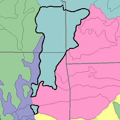
MLRA 112 - Cherokee PrairiesKansas, Missouri, and Oklahoma59,410 km2 (22,940 mi2) |
|
Soils:
Most of the soils are Aqualfs and Udolls. They are shallow to deep and medium textured and moderately fine textured. These soils have a thermic temperature regime, an aquic or udic moisture regime, and mixed mineralogy. Somewhat poorly drained nearly level and gently sloping Albaqualfs (Parsons and Taloka series), Argiaquolls (Woodson series), and Argialbolls (Hartwell series) are on clay-mantled uplands. Moderately well drained and well drained, gently sloping and sloping Paleudolls (Dennis and Okemah series), Hapludalfs (Barden and Liberal series), and Argiudolls (Bates and Eram series) are on uplands underlain by silty and sandy shale and sandstone. Well drained, gently sloping Argiudolls (Lula and Catoosa series) are underlain by limestone and are on uplands; shallower and more stony Argiudolls (Clareson series), Haplustolls (Shidler series), and Hapludolls (Coweta and Collinsville series) are on steeper slopes of limestone, sandstone, and loamy shale. Gently sloping to moderately sloping clayey Argiudolls (Summit series) are underlain by clayey shale and clay beds and are on foot slopes. Haplaquolls (Osage series), Hapludolls (Verdigris and Wynona series), and Ochraqualfs (Hepler series) are on the flood plains of most streams.
Soil Landscapes | Soil Climates | Soil Datasets | Personnel | Site Map
Comments and Questions
12/16/98