


|
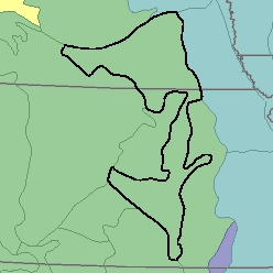
MLRA 75 - Central Loess PlainsKansas and Nebraska34,840 km2 (13,450 mi2) |
|
Water:
The moderate but somewhat erratic precipitation is the source of water for grain crops, native grasses, and pasture. In the northwest, the Platte River supplies some water for irrigation. Ground water that is hard but otherwise of good quality is abundant in the sand and gravel underlying part of the area. Adequate quantities of ground water are available for irrigation in the northern part. Ground water is scarce in areas where shale and clay are near the surface.
Soil Landscapes | Soil Climates | Soil Datasets | Personnel | Site Map
Comments and Questions
12/16/98