


|
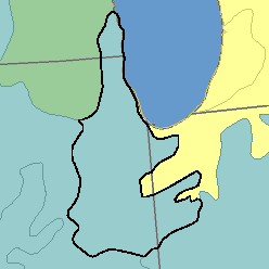
MLRA 110 - Northern Illinois and Indiana Heavy Till PlainIllinois, Indiana, and Wisconsin26,350 km2 (10,170 mi2) |
|
Soils:
Most of the soils are Udolls, and some are Aquolls. They are deep and moderately deep, fine, moderately fine, and medium textured and have a mesic temperature regime and mixed or illitic mineralogy. Well drained, gently sloping and moderately sloping Argiudolls (Saybrook and Varna series) are on the thinly loess-covered glacial till uplands. Somewhat poorly drained Argiudolls (Elliott, Swygert, and Clarency series) are nearly level or gently sloping. Poorly drained Haplaquolls (Ashkum, Bryce, and Drummer series) are on flats and in depressions. Very poorly drained Medisaprists (Houghton and Lena series) are in wet depressions, but they are not extensive. On outwash underlain by silt, sand, and gravel are loamy, well drained and moderately well drained Argiudolls (Plano, Proctor, and Warsaw series), somewhat poorly drained Arguidolls (Brenton and Elburn series), and well drained Hapludalfs (Fox series). Well drained and moderately well drained, gently sloping to strongly sloping Hapludalfs (Morley and Miami series) are on uplands covered by a thin mantle of glacial till; somewhat poorly drained Ochraqualfs (Blount series) are associated soils in nearly level areas.
Soil Landscapes | Soil Climates | Soil Datasets | Personnel | Site Map
Comments and Questions
12/16/98