


|
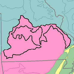
MLRA 116B - Ozark BorderMissouri35,470 km2 (13,690 mi2) |
|
Soils:
Most of the soils are Udalfs or Udults. They are moderately deep, medium textured to fine textured, cherty, limestone soils that are partly covered with a thin mantle of loess. They have a mesic temperature regime, an udic moisture regime, and siliceous or mixed mineralogy. Well drained, nearly level to moderately sloping Fragiudalfs (Hobson, Lebanon, Viraton, and Wilderness series), poorly drained, nearly level to moderately sloping Fragiaqualfs (Bado and Gerald series), and well drained Fragiudults (Captina and Nixa series) are on the broad tops of upland ridges. Well drained Hapludalfs (Barco, Bardley, and Bolivar series) are also on upper parts of ridgetops and side slopes on the uplands, and well drained Paleudalfs (Eldon and Goss series) and Paleudults (Clarksville series) are on the steeper and lower parts of side slopes and hillsides. Well drained, nearly level Hapludolls (Cedargap series) and Udifluvents (Elsah and Sharon series) are on bottom lands. Well drained Hapludalfs (Ashton, Razort, and Waben series) and Paleudalfs (Britwater series) occupy stream terraces.
Soil Landscapes | Soil Climates | Soil Datasets | Personnel | Site Map
Comments and Questions
12/16/98