


|
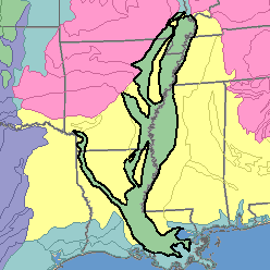
MLRA 131 - Southern Mississippi Valley AlluviumArkansas, Mississippi, Missouri, and Tennessee93,600 km2 (36,140 mi2) |

|
Elevation and Topography:
Elevation is at sea level in the south and increases gradually to about 200 m in the north. The area consists of level to gently sloping broad flood plains and low terraces. Most of the area is flat. The only noticeable slopes are sharp terrace scarps and natural levees that rise sharply to several meters above adjacent bottom lands or stream channels. Swamps are significant in the extreme southern part in Louisiana.
Soil Landscapes | Soil Climates | Soil Datasets | Personnel | Site Map
Comments and Questions
12/16/98