


|
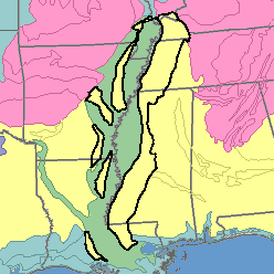
MLRA 134 - Southern Mississippi Valley Silty UplandsArkansas, Kentucky, Louisiana, Mississippi, and Tennessee51,410 km2 (19,850 mi2) |
|
Water:
Precipitation and ground water are abundant. On the uplands shallow wells, cisterns, ponds and rural water systems are the main sources of water for domestic use and livestock. Shallow wells provide small quantities of water, but deep wells in underlying sand and gravel yield large quantities. Most streams are small and flow intermittently. They flow most of the time in winter and in spring but only during and immediately after storms in summer and in autumn.
Soil Landscapes | Soil Climates | Soil Datasets | Personnel | Site Map
Comments and Questions
12/16/98