


|
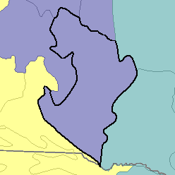
MLRA 55C - Southern Black Glaciated PlainsSouth Dakota20,240 km2 (7,810 mi2) |
|
Water:
In most years precipitation is inadequate for maximum crop production. Perennial streams are few and widely spaced and are little used for irrigation. Water for livestock is stored in ponds and small reservoirs on individual farms and ranches. Sandstone underlying part of the area yields large quantities of highly mineralized artesian water, but the shale yields very little water. Water from reservoirs on the Missouri River is used for irrigation on the adjacent upland soils.
Soil Landscapes | Soil Climates | Soil Datasets | Personnel | Site Map
Comments and Questions
12/16/98