


|
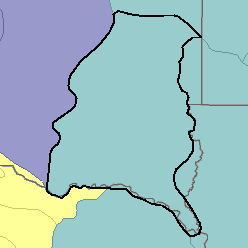
MLRA 102B - Loess Uplands and Till PlainsIowa, Minnesota, South Dakota, and Nebraska43,790 km2 (16,910 mi2) |
|
Soils:
Most of the soils are Ustolls. They are deep and silty and loamy and have a mesic temperature regime, an ustic moisture regime, and mixed mineralogy. Well drained, nearly level to moderately sloping Haplustolls (Belfore, Moody, and Nora series) are on loess uplands, and Ustorthents (Crofton series) are on the steeper parts of the landscape. Other well drained, nearly level to moderately sloping Haplustolls (Clarno, Egan, Ethan, and Wentworth series) are on sites in the till plains, and Ustorthents (Betts series) are on the steeper slopes. Poorly drained Argialbolls (Tetonka series), Argiaquolls (Worthing series), and Haplaquolls (Whitewood series) are in upland depressions. Fluvaquents (Albaton series), Haplaquolls (Lamo and Luton series), and Udifluvents (Haynie series) are dominant on the stream valley floors and bottom land of the Missouri River.
Soil Landscapes | Soil Climates | Soil Datasets | Personnel | Site Map
Comments and Questions
12/16/98