


|
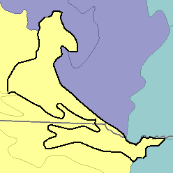
MLRA 63B - Southern Rolling Pierre Shale PlainsSouth Dakota and Nebraska28,400 km2 (10,970 mi2) |
|
Water:
In most years precipitation is inadequate for maximum plant growth. The reservoirs on the Missouri River are prominent features on the eastern border. There are few shallow-water developments, and most water for livestock comes from surface runoff that flows into dams or from deep artesian flows.
Soil Landscapes | Soil Climates | Soil Datasets | Personnel | Site Map
Comments and Questions
12/16/98