

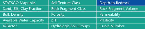

The location of bedrock with respect to the land surface is often needed
in surface and subsurface environmental modeling applications. The
STATSGO database contains information on the range of depth-to-bedrock
for each map unit component.
Sand, Silt, Clay Fractions | Rock Fragment Class | Rock Fragment Volume
Bulk Density | Porosity | Permeability
Available Water Capacity | pH | Plasticity
K-Factor | Hydrologic Soil Groups | Curve Numbers
Soil Landscapes | Soil Climates | Soil Datasets | Personnel | Site Map
Comments and Questions
4/19/99