


This dataset contains files specifying the 10,500 mapunits defined for the 48 conterminous states for the State Soil Geographic (STATSGO) soils data compiled by the Natural Resources Convservation Service (NRCS) of the USDA.
To increase the compatibility with different types of data analysis
software, the dataset is available in several different file
formats. These include both Arc/Info polygon format and a gridded
version at 1-km resolution. When a 1-km grid cell contains portions of
two or more mapunits, the cell has been assigned to the mapunit which
occupies the largest fraction of the cell. The gridded data are
available in two formats: Arc/Info GRID format, and a two-dimensional
array of 16-bit binary integers, with the most significant byte first.
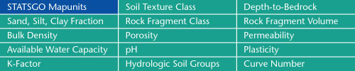
Sand, Silt, Clay Fractions | Rock Fragment Class | Rock Fragment Volume
Bulk Density | Porosity | Permeability
Available Water Capacity | pH | Plasticity
K-Factor | Hydrologic Soil Groups | Curve Numbers
Soil Landscapes | Soil Climates | Soil Datasets | Personnel | Site Map
Comments and Questions
4/19/99