


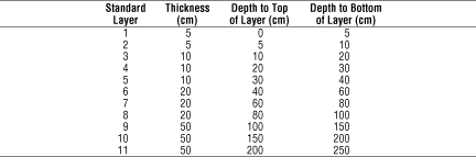
The volume percent of sand, silt, and clay in the soil fraction which passes a No. 10 (2 mm) sieve was estimated for each of 11 standard layers for each map unit of each state using the STATSGO Component and Layer tables.
Although the STATSGO database contains information on clay content and sieved samples on a component layer basis which could allow the subsequent determination of sand and silt fractions, preliminary examination of the database indicated that calculations based on these variables would not provide consistent results. Specifically, percentages of the sand, silt, and clay fractions should total to 100 percent of the soil material less than with particle sizes less than 2 mm. Initial calculuations using these variables from the STATSGO data for Pennsylvania revealed that the < 2 mm fractions rarely summed to 100 percent. Apparently, different laboratory methods are used to determine these values and no internal consistency checks are made within the soil characterization information that is used to build the STATSGO database.
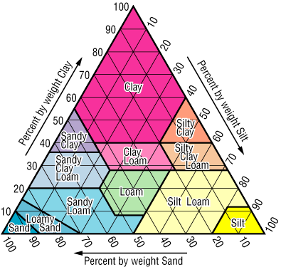
As an alternative, the USDA soil texture triangle, which gives the ranges of sand, silt, and clay percents for each of the 12 standard texture classes, was used to estimate the relative amounts of soil fractions by taking the values at the midpoint of the polygon which delimits each texture class. The STATSGO Layer table entries for each component use the TEXTURE1 variable for each layer to record the dominant rock fragment and texture class in a combined description (e.g. "extremely cobbly-sandy loam"). The Layer table also records the depth to the top and bottom of each layer. The Component table entries for each component of each map unit use the COMPPCT variable to record the approximate percent of the area of the map unit which is covered by that component; this table also reports the minimum and maximum depth to bedrock for the component.
- Translating the combined texture description in TEXTURE1 for
each STATSGO component layer to a standard USDA texture triangle
class.
- Estimating the amount of sand, silt, and clay in the less than 2
mm soil fraction for each component layer.
- Determining the contribution of each component layer to the 11
standard layers.
- For each mapunit, combining the contributions of all components to
determine the dominant texture class for each standard layer.
The relative amounts of sand, soil, and clay in the < 2 mm fraction of the component layer was then estimated using the following table:
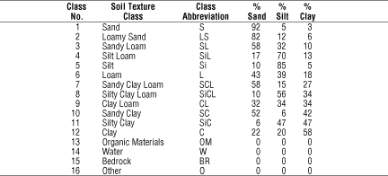
If the TEXTURE1 variable translated to a non-soil class other than water, (organic material, bedrock, or "other") the layer was assigned values of zero for all sand, silt, and clay.
To determine the contribution of each component of a given map unit to the standard layers, the layers defined in the Layer table for the component were compared with each standard layer. If the standard layer was entirely included within one of the component layers, the sand, silt, and clay percentages for the TEXTURE1 value for the layer were multiplied by the COMPPCT value to determine the weighted contribution of the component to the standard layer. If the standard layer overlapped two or more component layers, the soil fraction percents for each component layer were first weighted in proportion to the amount of overlap before multiplication by the COMPPCT value.
When the Component table specified a mean depth-to-bedrock above the bottom of the lowest standard layer, the component was assumed to be composed of all rock below this layer unless a layer table entry explicitly specified a non-rock layer extending below this level. When the bottom of the deepest component layer was above mean bedrock, the layer was assumed to extend down to mean bedrock. For many components, a depth-to-bedrock of 60 inches (1.52 m) was used simply to indicate that the soil was not examined below this depth. As a result, the computed sand/silt/clay values for the two lowest standard layers (1.5 to 2.5 m) will be misleading, since in may cases rock does not actually occur at the specified depth.
After all components for a map unit were processed, the weighted contributions of each component were totalled for each standard layer. The percent of the map unit area covered by non-water components was determined. If the total of sand, silt, and clay percents for a standard layer was less than one-half this value, the sand, silt, and clay percentages were all set to zero for the layer. Otherwise, if the total of sand, silt, and clay was less than 100%, each value was divided by the total to make the new values add up to 100% before rounding..
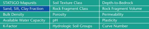
Sand, Silt, Clay Fractions | Rock Fragment Class | Rock Fragment Volume
Bulk Density | Porosity | Permeability
Available Water Capacity | pH | Plasticity
K-Factor | Hydrologic Soil Groups | Curve Numbers
Soil Landscapes | Soil Climates | Soil Datasets | Personnel | Site Map
Comments and Questions
4/19/99