


The pH Coverages are available in both gridded and vector formats in the following map projections:
Lambert Azimuthal
 Projection Parameters
Data Files
Projection Parameters
Data Files
Albers Equal Area
- Projection Parameters
Data Files
Geographic Coordinates (Latitude/Longitude)
- Projection Parameters
Data Files
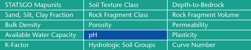
Sand, Silt, Clay Fractions | Rock Fragment Class | Rock Fragment Volume
Bulk Density | Porosity | Permeability
Available Water Capacity | pH | Plasticity
K-Factor | Hydrologic Soil Groups | Curve Numbers
Soil Landscapes | Soil Climates | Soil Datasets | Personnel | Site Map
Comments and Questions
8/27/2001