


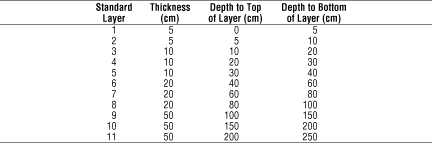
The dominant rock fragment modifier class for each of 11 standard layers was determined for each map unit of each state using the STATSGO Component and Layer tables. The standard layers were introduced because of the wide variation in the number, thickness, and depth to top and bottom of soil layers in the STATSGO data from one soil component to another, even within the same map unit.
The Layer table entries for each component use the TEXTURE1 variable for each layer to record the dominant rock fragment and texture class in a combined description (e.g. "extremely cobbly-sandy loam"). The Layer table also records the depth to the top and bottom of the each layer. The Component table entries for each component of each map unit use the COMPPCT variable to record the percent of the area of the map unit which is covered by that component; this table also reports the minimum and maximum depth-to-bedrock for the component.
Determining the dominant rock fragment class for each of a set of standard layers required three main steps:
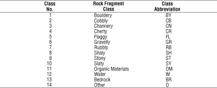
- Translating the combined texture description in TEXTURE1 to a
standard rock fragment modifier class.
- For each component, determining the contribution of each component
layer to the 11 standard layers.
- For each mapunit, combining the contributions of all components to
determine the dominant rock fragment class for each standard layer.
To determine the contribution of each component of a given map unit to the standard layers, the layers defined in the Layer table for the component were compared with each standard layer. If the standard layer was entirely included within one of the component layers, the fragment class associated with the TEXTURE1 value for the layer was multiplied by the COMPPCT value to determine the fractional contribution of the fragment class to the standard layer. If the standard layer overlapped two or more component layers, the fragment classes for each component layer were first weighted in proportion to the amount of overlap before multiplication by the COMPPCT value.
After all components for the map unit were processed, the fragment class for which the total fractional contributions from all components in the map unit was largest was determined for each standard layer and entered as the dominant fragment class for that layer. It must be emphasized that other fragment classes are often present in the layer -- in some cases, the dominant class may be representative of less than half the map unit's area.
Many Component table entries for depth to bedrock used 60 inches (1.5 m) to infer that bedrock was not encountered within this distance of the surface. In many cases, the layer table for such a component included a non-rock layer extending below the specified maximum depth-to-bedrock. When the Layer table did contain layers extending below the depth to bedrock reported for the component, these layers were used, and the bedrock was assumed to actually start immediately below the deepest such layer. When the bottom of the deepest layer was above the reported bedrock, the bottom layer was extended to the bedrock depth or the bottom of the deepest standard layer (2.5 m), whichever was less. In a large proportion of cases, however, an entry of "bedrock" in the two lowest standard layers (1.5 to 2.5 m) is misleading, since the soil or rock was not examined to that depth.
Sand, Silt, Clay Fractions | Rock Fragment Class | Rock Fragment Volume
Bulk Density | Porosity | Permeability
Available Water Capacity | pH | Plasticity
K-Factor | Hydrologic Soil Groups | Curve Numbers
Soil Landscapes | Soil Climates | Soil Datasets | Personnel | Site Map
Comments and Questions
4/19/99